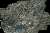
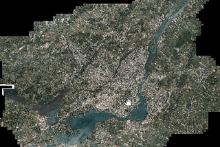
PinnedZachary DézielNot the Shortest Path: Convert a Directory of Satellite Images to a Cloud Optimized Geotiff (COG)Not the Shortest Path — Ep.1 🌎 📡 💾4 min read·Jan 16, 2022--1--1
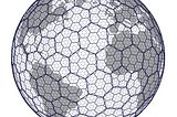
PinnedZachary DézielHexagons — Start With WhyThe Reasons Behind the Hexagon Hype10 min read·Oct 13, 2021----
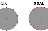
PinnedZachary DézielLegend of the Buffer — Beware of 3 Important MistakesExposing a far too frequent and erroneous geospatial algorithm5 min read·Feb 2, 2021----
Zachary DézielNot the Shortest Path: Animating Geospatial Data in BlenderNot the Shortest Path — Ep. 2 🌎 📡 💾7 min read·Feb 14, 2022----
Zachary DézielNot the Shortest Path: Convert GPX Files for 3D AnimationNot the Shortest Path — Ep. 1 🌎 📡 💾8 min read·Jan 31, 2022----
Zachary DézielWhy Build Products For Non-Geo ExpertsVertically integrated solutions will overrule generalist solutions in Geospatial3 min read·Oct 20, 2021----
Zachary DézielinCARRE4What happens when you call a Shapely spatial function?Exploring the design of a focused geospatial library4 min read·Feb 12, 2021----
Zachary DézielBehind the Scenes of The Forgotten Adapter in GeospatialApplications of the Adapter Design Pattern in Geospatial4 min read·Jan 29, 2021----
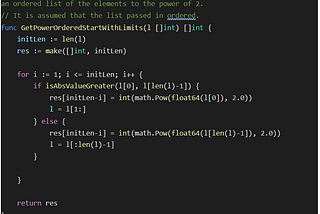
Zachary DézielinLevel Up CodingThe Ordered Power ProblemA Detour in Computational Complexity7 min read·Jan 20, 2021----